https://files-p.pxsol.com/4418/company/library/user/1208134349891cb9f1a4add6c514621e78ab0452d37.jpg

Excursions

Explore the wonders of El Chaltén: A complete guide to the best hikes and trails
CHORRILLO DEL SALTO
CHORRILLO DEL SALTO

7KM – 4 HRS – EASY

This pleasant hike is perfect for a first glimpse into the natural environment of El Chaltén, traversing a hillside forest on an easy trail. At the end of the route, a beautiful waterfall and its stream invite you to pause and contemplate the surroundings within the native forest.

The trail begins in El Chaltén, at the end of Avenida San Martín, at the very start of the trail to Laguna De los Tres; take the path that heads to the right.

Shortly after, the trail climbs a slope that soon descends again until reaching the gravel road that leads to Lago del Desierto (Provincial Route 41). Shortly after starting your walk along the route, you'll find a sign on your right indicating the entrance to a bike path (a path for bicycles only, do not enter), and a few minutes later, another sign on your left indicating that the trail to Chorrillo del Salto continues, re-entering the foothills area and passing through a small, low-lying forest of ñire trees. In less than half an hour, you'll reach the final section of the trail, where there's a parking area; this means you can also get here by car or bicycle. The final section of the trail is for pedestrians only, as bicycles are prohibited. This beautiful path is completely flat and surrounded by low trees. The distant sound of the waterfall signals that you are nearing the end of the trail. Magellanic Orchid Alongside the trees, depending on the season, you will find different flowers of the local vegetation, such as the beautiful Magellanic orchid. The waterfall is located at the very end of the Arroyo del Salto stream, before it flows into the De las Vueltas River. This hike is less than 4 km from El Chaltén.

CAPRI LAGOON
CAPRI LAGOON

7KM – 4 HRS – LOW DIFFICULTY

This hike begins at the end of Avenida San Martín, on the northern edge of the urban area of El Chaltén, bordering the National Park. Just before entering the trail, you'll see a parking area, and at the trailhead, a large information sign with a map of distances and times useful to consider before starting.

Trailhead Signage

The first kilometer of the trail follows a somewhat steep slope, until you reach the 'Mirador Río de las Vueltas' (Río de las Vueltas Viewpoint), a natural balcony with a spectacular view of the valley that you'll continue to enjoy for almost another hour.

Río de las Vueltas Viewpoint

The second kilometer of this hike has a gentler slope than the first kilometer, as you gain altitude along the western slope of the Río de las Vueltas valley, with a panoramic view of the Los Cóndores mountain range.

Río de las Vueltas Valley Turns

As you continue, the ñire trees become increasingly numerous. Upon reaching the sign indicating you have already walked 2 kilometers, you will be surrounded by increasingly taller lenga trees, which provide shelter on windy days.

Lenga Forest

Shortly after starting the third kilometer, you will see a large sign indicating the fork towards Laguna Capri (to the left) and the continuation towards Mirador Fitz Roy and Laguna De los Tres. This site is also a meeting point within the network of self-guided trails in the National Park.

Last kilometer of the trail

The last stretch of the trail reveals the hills behind the grove, as the descent towards the lagoon begins.

Fitz Roy Viewpoint

From the shore of the lagoon you will have a fantastic view of Mount Chaltén or Fitz Roy and its surrounding peaks, a place that invites you to stay and contemplate one of the classic postcards of El Chaltén. From there, you can return to the village or continue a few steps along the edge of the lagoon until you reach Laguna Capri Base Camp. Beyond this camp, the trail joins the one that leads to Laguna de los Tres, passing by Poincenot Camp. If you have an extra 40 minutes, don't miss the 'Fitz Roy Lookout,' a panoramic viewpoint with a sign that explains the mountain and glacial panorama before you. To get there, continue along the path that passes Laguna Capri Camp until you find another fork with a National Park sign indicating the return route to El Chaltén and the lookout to your left.

FOLD FLAT
FOLD FLAT

21 KM – 8 HRS – MEDIUM DIFFICULTY

The trail begins at the Ceferino Fonzo Visitor Center in the National Park, where a small gate indicates two paths: to the left, the trail to the Los Cóndores and Las Águilas viewpoints; and to the right, the trail to the Pliegue Tumbado and Laguna Toro / Paso del Viento.

This trail maintains a constant uphill slope of approximately 1100 meters in total, until reaching the viewpoint located about 1500 meters above sea level. Due to its high altitude, the absence of trees, and its complete exposure to the wind, you should be prepared with a windbreaker and warm clothing, as a light snowfall is not uncommon even in the middle of summer. Pampa de las Carretas: After an hour of hiking, the trail crosses a plain called Pampa de las Carretas, from where you can appreciate the imposing Huemul mountain, Lake Viedma to the south, and to the northwest, the full grandeur of the Andes Mountains unfolds, where Cerro Torre and Cerro Chaltén stand out. Lenga Forest: The trail then enters a beautiful forest, reaching an altitude of approximately 1000 meters above sea level, where the landscape changes abruptly: the trees give way to shrubs and vegetation. The path is low-lying, and among the numerous stones scattered along the way, it's possible to find marine fossils dating back 100 million years. The trail becomes less defined, but it continues to be marked with yellow poles until reaching the Mirador del Pliegue Tumbado (Tumbled Fold Viewpoint), which offers an incredible view of most of the mountains in the El Chaltén area, including the Fitz Roy River valley and Laguna Torre. The summit of Pliegue Tumbado requires another hour of hiking, ascending an additional 280 meters from the viewpoint, with a somewhat steep slope. The summit offers an extraordinary 360-degree panoramic view. This last section may be snow-covered, and in that case, travel is not recommended.

LAGUNA TOWER
LAGUNA TOWER

19 KM – 8 HOURS – MEDIUM DIFFICULTY

From El Chaltén, there are two trailheads leading to Laguna Torre; both trails merge 5 minutes from their starting point.

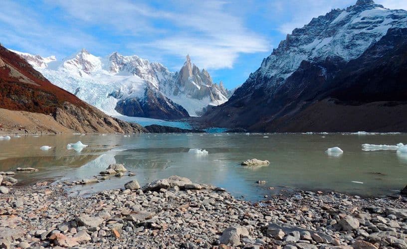
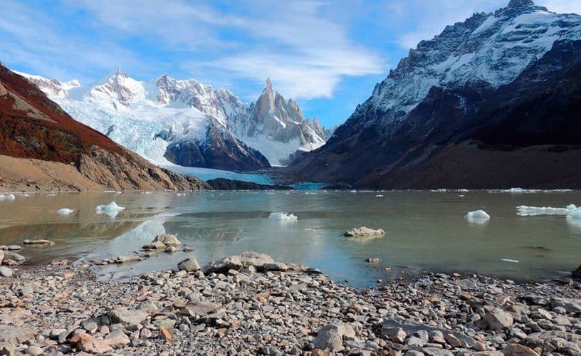
The trail enters the Fitz Roy River valley and continues upstream along the river to its source. Just 15 minutes into the hike, you reach the first viewpoint located in a gorge of the Fitz Roy River, offering a panoramic view of Cerro Solo, Cordón Adela, Cerro Torre, and Mount Fitz Roy. On the other side of the river is Margarita Waterfall. Mirador del Torre (Torre Viewpoint) Halfway along the trail, you'll reach a natural viewpoint with an unparalleled panoramic view of the Adela mountain range and Cerro Torre, and the granite spires that accompany it. The trail eventually crosses the De Agostini base camp, where it's possible to spend the night. Laguna Torre (Torre Lagoon) Leaving the base camp behind, the trail heads towards the frontal moraine, which you ascend to reach its crest after about 15 minutes. Mirador Maestri (Maestri Viewpoint) From there, you can descend to the lagoon, or continue along the same ridge for another 2 km to the Maestri viewpoint. This lagoon often has numerous icebergs gathered on its shores, calved from the face of the Grande Glacier. Icebergs at Laguna Torre. The hills are always viewed from the west, so they are only directly illuminated by the sun in the morning. You'll get the best photographs at dawn, when the granite's color saturates for a few minutes just as the sunlight first reaches them. This is reserved for those who spend the night at the De Agostini camp and wait for that magical moment with their camera ready at the crack of dawn. Sunrise at Laguna Torre. Recommendations: If you plan to stay or spend the night at the De Agostini camp, we suggest you carefully read the recommendations for your stay. While access to this viewpoint is possible most of the year, in winter it will always depend on the accumulation of snow or meltwater on the trail, especially on the final stretch. We recommend always checking trail conditions at the Los Glaciares National Park Visitor Center, located just before the entrance to the tourist village. Keep in mind that this is a hike that takes several hours, so if you are not staying overnight at the De Agostini campsite, we suggest starting very early, if possible before 8 a.m. during the summer months.

LAGOON OF THE 3
LAGOON OF THE 3

25 KM – 8 HRS – MEDIUM-HIGH DIFFICULTY

The trailhead begins at the end of Avenida San Martín, where the town limits of El Chaltén end and the parking area is located next to the old 'Puesto Amarillo' (Yellow Post). During the first hour of the hike, the slope is somewhat steep, and you will reach a natural viewpoint overlooking the De las Vueltas River Valley.

De las Vueltas River Valley

In a few more minutes, you will enter the Del Salto stream valley, heading towards Mount Fitz Roy. The ñire trees become increasingly numerous around the trail, and approximately an hour and a half into the journey, you reach a well-marked natural rocky viewpoint with a sign that explains the mountainous and glacial panorama unfolding before you. The path continues, always following the Del Salto stream upstream to the drainage area of the Madre and Hija lagoons. About 4 hours after leaving El Chaltén, you first reach the Poincenot base camp (one of the most popular campsites in the National Park) and then, after crossing the Blanco River, the Río Blanco base camp (for climbers only).

Arroyo Del Salto

From here, the trail continues with a somewhat steep incline of approximately 400 meters of elevation gain to Laguna De los Tres, which will require a little over an hour of effort.

Slope of the final section of the trail

The trail ends at the ancient moraine ridge (a huge arc-shaped formation that currently contains the lagoon, formed by the action of glacial advance and subsequent retreat), with an extraordinary view of Laguna De los Tres and Glacier. This is the closest view of the granite face of Mount Fitz Roy and its surrounding peaks.

Laguna De los Tres

If you make the effort to arrive at sunrise, the reward will be twofold, as you will be able to witness the extraordinary moment when the hills are tinged red by the first rays of the sun.

Sunrise at Laguna De los Tres

Descending the moraine and skirting the lagoon to its outlet, you will find a path that will lead you to another impressive view: the desolate Laguna Sucia and its hanging glaciers.

Laguna Sucia

While access to this viewpoint is possible year-round, from April to October it will depend on the accumulation of snow on the trail, especially along the route final.

CONTACT US
Fill out the form and we'll get back to you as soon as possible.